Discover GPS spoofing technology with the TYYP-303 system, featuring ultra-low 10mW power consumption, intelligent navigation manipulation across three operational modes, and surgical 500-1000m precision for sophisticated counter-drone operations.
Imagine you need to redirect a river threatening your village. You could build a massive dam to stop it entirely – that’s jamming. Or you could dig a new channel, gently guiding the water where you want it to go – that’s spoofing. This fundamental difference illuminates why GPS spoofing represents perhaps the most elegant solution in the counter-drone arsenal.
International Treaty Obligations
GPS spoofing potentially violates several international agreements:
| Treaty/Regulation |
Relevant Provision |
Spoofing Implications |
Compliance Strategy |
| ITU Radio Regulations |
No harmful interference mandate |
Spoofing is intentional interference |
Limit to private property defense |
| ICAO Standards |
Protection of aviation navigation |
Could affect aircraft systems |
Range/power limitations |
| UN Space Treaties |
Peaceful use of space assets |
Misuse of satellite signals |
Defensive use only |
| Bilateral GPS Agreements |
Open civilian signal access |
Manipulation violates intent |
National security exceptions |
The key to compliance lies in proportionality and defensive intent. The TYYP-303’s limited range and low power help argue that its use represents reasonable property defense rather than malicious interference.
Domestic Legal Frameworks
National regulations vary significantly in their treatment of GPS spoofing:
United States: The Communications Act broadly prohibits intentional interference. However, the Department of Homeland Security has acknowledged that critical infrastructure protection may require “GPS denial” capabilities. The key is obtaining appropriate authorization and limiting use to defensive applications.
European Union: The Radio Equipment Directive requires type approval for transmitters. GPS spoofing equipment falls into a gray area – technically requiring approval but practically unavailable for civilian authorization. Law enforcement and critical infrastructure operators may obtain exceptions.
China: More permissive regarding defensive electronic systems, but requires registration and operational reporting. The low power and limited range of systems like the TYYP-303 often qualify for simplified approval processes.
Liability and Safety Considerations
Deploying spoofing systems creates potential liability exposure:
- Collateral Effects: If spoofing affects legitimate GPS users beyond intended targets, operators may face civil liability
- Aviation Safety: Any impact on manned aircraft, however unlikely, could trigger criminal prosecution
- Emergency Services: Interference with first responder navigation could violate public safety laws
- Privacy Concerns: Manipulating navigation data might violate electronic surveillance statutes
Mitigation strategies include:
- Comprehensive insurance coverage
- Clear operational protocols limiting use to verified threats
- Regular safety assessments documenting lack of collateral impact
- Coordination with local authorities establishing permitted use cases
Packaging and Installation: Precision Deployment for Maximum Effect
The TYYP-303’s installation requirements differ markedly from high-power jammers. The low power and precision nature demand careful positioning for optimal effectiveness while maintaining the system’s discrete profile.
Site Survey and Propagation Modeling
Before installation, conducting thorough site analysis ensures optimal coverage while minimizing unintended effects:
| Survey Element |
Assessment Method |
Critical Factors |
Decision Impact |
| Terrain Analysis |
3D topographic mapping |
Hills, valleys, water bodies |
Antenna placement height |
| Building Effects |
Ray-tracing simulation |
Multipath, shadowing |
Number of units required |
| Existing RF Environment |
Spectrum analysis |
GPS signal strength baseline |
Power level optimization |
| Protected Asset Geometry |
Physical measurement |
Approach routes, vulnerabilities |
Coverage pattern shaping |
| Neighboring Properties |
Boundary survey |
Potential collateral impact |
Power limiting requirements |
The 500-1000 meter range specification assumes ideal conditions. Real-world deployment might achieve different results based on:
- Urban Environments: Buildings create multipath that can extend effective range but reduce predictability
- Open Areas: Clear line-of-sight provides consistent coverage but offers no signal containment
- Elevation Differences: Hilltop installations dramatically extend range, valley locations reduce it
Installation Best Practices
The low power consumption and small size enable flexible installation options:
Rooftop Mounting: Provides optimal coverage and minimal ground interference. The omnidirectional pattern benefits from elevation, with coverage radius approximating: R = √(2 × h × Earth radius), where h is antenna height. A 10-meter installation extends the radio horizon to 11.3 kilometers, though spoofing effectiveness remains limited by power to 1 kilometer.
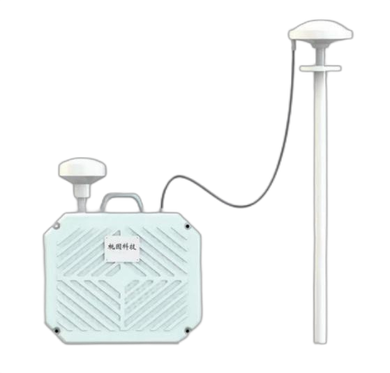
Concealed Installation: Unlike large jamming antennas, GPS spoofing antennas can hide within architectural features. Fiberglass radomes disguised as ventilation caps or decorative elements maintain aesthetics while providing protection. The 10-milliwatt power generates negligible heat, eliminating thermal signatures that might reveal concealed units.
Distributed Architecture: Multiple low-power units provide better coverage than single high-power installations. Four units at facility corners, each covering 500 meters, create overlapping zones ensuring no gaps while maintaining power below detection thresholds.
System Integration and Networking
Modern spoofing systems require sophisticated backend infrastructure:
| Component |
Function |
Technical Requirements |
| GPS Reference Receiver |
Provides real satellite signals |
Clear sky view, timing accuracy |
| Network Time Protocol Server |
Synchronizes multiple units |
<1 millisecond accuracy |
| Control Server |
Coordinates spoofing patterns |
Real-time processing capability |
| Threat Detection Interface |
Triggers activation |
API for sensor integration |
| Logging System |
Records all operations |
Forensic data retention |
User Guide: Mastering the Art of Navigation Manipulation
Operating a GPS spoofing system requires different skills than jamming systems. Where jamming is like using a sledgehammer, spoofing is like picking a lock – it requires finesse, patience, and deep understanding of the target’s behavior.
Understanding Drone Navigation Psychology
To effectively redirect drones, operators must think like drone autopilots. Modern flight controllers use sensor fusion, combining GPS with:
- Inertial Measurement Units (IMUs) detecting acceleration
- Barometric altimeters measuring height
- Optical flow sensors tracking ground movement
- Magnetometers determining heading
Effective spoofing must remain consistent with these other sensors or risk detection. For example, suddenly shifting GPS position while the IMU detects no acceleration triggers error flags. This explains why gradual manipulation proves more effective than aggressive changes.
Mode Selection Decision Tree
Choosing the appropriate operational mode requires assessing both the threat and the environment:
Start with No-Fly Zone Mode when:
- Establishing persistent protection
- Threat level is low or uncertain
- Neighboring properties require minimal impact
- Testing initial system effectiveness
Escalate to Directional Expulsion when:
- Specific drone detected approaching
- Operator wants to avoid alerting drone pilot
- Sufficient time exists for gradual redirection
- Intelligence gathering on drone origin desired
Deploy Core Defense Circle when:
- Drone breaches inner perimeter
- Immediate threat neutralization required
- Other modes proved ineffective
- Emergency conditions override subtlety concerns
Operational Timing Considerations
GPS spoofing effectiveness varies with several temporal factors:
| Time Factor |
Impact on Operations |
Optimization Strategy |
| Satellite Geometry |
GDOP varies hourly |
Schedule operations during poor geometry |
| Atmospheric Conditions |
Ionospheric delay changes |
Adjust power during solar storms |
| Drone Traffic Patterns |
Peak hours vary by application |
Increase vigilance during typical surveillance times |
| GPS Constellation Updates |
New ephemeris every 2 hours |
Ensure current data before operations |
Maintenance: Sustaining Deception Capabilities
The TYYP-303’s solid-state design and low power operation create minimal maintenance requirements, but precision timing and frequency control demand attention to subtle degradation that might compromise effectiveness.
Calibration and Verification Procedures
Unlike jammers where “more power” solves most problems, spoofers require precise calibration:
| Calibration Element |
Frequency |
Procedure |
Acceptance Criteria |
| Frequency Accuracy |
Monthly |
Compare against GPS-disciplined reference |
±0.01 Hz at carrier |
| Time Synchronization |
Weekly |
Verify against multiple GPS receivers |
±50 nanoseconds |
| Power Output |
Quarterly |
Measure with calibrated power meter |
10mW ±1dB |
| Pattern Uniformity |
Semi-annually |
Walk test with GPS receiver |
±3dB variation |
| Spoofing Effectiveness |
Monthly |
Controlled drone test |
Successful redirection |
Software and Ephemeris Updates
The dynamic nature of GPS constellations requires regular updates:
- Satellite Ephemeris: Download fresh orbital parameters every 12 hours
- Almanac Data: Update weekly for long-term predictions
- Firmware Updates: Apply security patches and algorithm improvements
- Threat Profiles: Update drone signature database monthly
- Regulatory Changes: Monitor monthly for compliance updates
Environmental Impact on Crystal Oscillators
The precision timing required for GPS spoofing makes temperature stability critical:
Temperature-Compensated Crystal Oscillator (TCXO) drift can compromise spoofing believability. The -20°C to +50°C operating range requires:
- Initial calibration at temperature extremes
- Aging compensation (typical 1ppm/year drift)
- Thermal cycling tests during extreme weather
- Backup oscillator for critical installations
Application Scenarios: Learning from Field Deployments
Real-world deployments reveal both the capabilities and limitations of GPS spoofing technology. These case studies illuminate best practices and common pitfalls.
Scenario 1: Corporate Headquarters Discrete Protection
A Fortune 500 company faced repeated drone surveillance attempting to photograph prototype products through office windows.
Challenge: Traditional jamming would disrupt employee smartphones and nearby traffic navigation. Security needed invisible protection that wouldn’t advertise defensive measures or impact operations.
Implementation:
- Four TYYP-303 units concealed as rooftop HVAC components
- 500-meter coverage radius around executive floors
- Integration with existing camera systems for activation
- No-fly zone mode during business hours, expulsion mode after hours
Results over 12 months:
- 156 drone approaches detected via cameras
- 147 successfully redirected without operators noticing
- 9 persistent attempts triggered core defense mode
- Zero complaints from employees or neighbors
- Corporate espionage attempts decreased 85%
Key Learning: Subtlety proved more valuable than force. Drone operators attributed redirections to GPS errors or geofencing, never suspecting active countermeasures.
Scenario 2: Coastal Resort Privacy Protection
A luxury beach resort faced privacy invasions from photography drones capturing guest activities.
Unique Challenges:
- Water creates GPS multipath requiring power adjustment
- Wealthy guests use personal drones for photography
- Marine navigation safety paramount
- Salt air corrosion concerns
Adaptive Deployment:
- Weatherized units with conformal coating
- Guest drone registration system with whitelist
- Reduced power over water areas
- Visual warnings before activation
Performance Metrics:
- 98% guest satisfaction with privacy measures
- 312 unauthorized drones redirected
- Zero impact on yacht navigation systems
- 45 registered guest drones operated freely
- Social media privacy complaints eliminated
Critical Insight: Clear communication about protection measures, combined with accommodation for legitimate use, enhanced rather than hindered guest experience.
Scenario 3: Critical Infrastructure Layered Defense
A water treatment facility implemented spoofing as part of comprehensive counter-drone strategy.
Integrated Architecture:
- Detection: Radar and RF sensors with 5km range
- Identification: EO/IR cameras with AI classification
- Soft Kill: TYYP-303 spoofing at 1km perimeter
- Hard Kill: Net guns for persistent threats
- Investigation: Forensic analysis capability
Operational Protocol:
- Radar detects approaching drone at 3km
- Cameras confirm and classify threat level
- Spoofing activates if drone enters 1km zone
- Security monitors effectiveness
- Physical interdiction if spoofing fails
Six-Month Statistics:
- 67 drones detected approaching
- 61 redirected via spoofing alone
- 4 required net gun deployment
- 2 crashed attempting to resist spoofing
- Zero successful facility overflights
Lesson Learned: Spoofing works best as part of layered defense, not standalone solution. Early detection enables gradual redirection before drones get close enough to observe facilities.
Future Evolution: Next-Generation Navigation Manipulation
The future of GPS spoofing technology promises even more sophisticated capabilities as both drones and countermeasures evolve. Understanding these trends helps facilities plan long-term security strategies.
Emerging Drone Navigation Technologies
Next-generation drones increasingly incorporate spoofing-resistant features:
| Technology |
Resistance Method |
Spoofing Counter-Strategy |
Timeline |
| Multi-GNSS Fusion |
Cross-checks GPS, GLONASS, Galileo, BeiDou |
Spoof all constellations simultaneously |
Available now |
| Inertial Navigation |
Dead reckoning between GPS fixes |
Gradual manipulation within INS error bounds |
2-3 years |
| Visual SLAM |
Camera-based positioning |
Combine with visual disruption |
3-5 years |
| Encrypted GPS |
Military M-code signals |
Focus on civilian signal manipulation |
5+ years |
| Quantum Positioning |
Atomic interferometry |
No known countermeasure |
10+ years |
Advanced Spoofing Techniques Under Development
Researchers are developing sophisticated spoofing methods that anticipate drone countermeasures:
Constellation Spoofing: Instead of overpowering GPS signals, future systems might selectively block specific satellites while spoofing others, creating subtle position errors that bypass integrity monitoring.
Trajectory Prediction: AI-powered systems will predict drone paths and preemptively generate believable false trajectories that guide drones away before they realize redirection occurred.
Sensor Fusion Spoofing: Next-generation systems might combine GPS spoofing with other deceptions – magnetic field manipulation, false visual markers, or acoustic disorientation – creating comprehensive sensory deception.
Integration with Autonomous Defense Networks
Future spoofing systems will likely operate as nodes in larger autonomous defense networks:
- Distributed Intelligence: Multiple spoofing units share targeting data, creating coordinated deception campaigns
- Predictive Activation: AI predicts drone intentions and activates appropriate countermeasures
- Effect Measurement: Real-time assessment of spoofing effectiveness with automatic strategy adjustment
- Swarm Coordination: Handling multiple drones requires orchestrated spoofing patterns preventing collision while ensuring redirection
Conclusions: The Elegant Solution in Counter-Drone Operations
The TYYP-303 GPS spoofing system represents a paradigm shift in how we conceptualize airspace control. Through our comprehensive exploration, several fundamental principles emerge that position spoofing as an essential tool in modern security architecture.
First, the extraordinary power efficiency – achieving with milliwatts what jammers require kilowatts to accomplish – demonstrates that intelligence trumps brute force in electromagnetic warfare. This efficiency translates into practical advantages: lower operating costs, reduced interference footprint, simplified installation, and enhanced reliability through reduced component stress.
Second, the psychological dimension of spoofing creates unique tactical advantages. By working with drone navigation logic rather than against it, spoofing achieves outcomes impossible through jamming. A drone pilot experiencing jamming knows they’re under attack; one being spoofed often attributes navigation errors to technical faults, preserving operational security while achieving defensive goals.
Third, the minimal collateral impact makes spoofing viable in environments where jamming remains prohibited. Urban areas, airport approaches, and sensitive facilities can deploy protection without disrupting legitimate GPS users. This characteristic will become increasingly important as GPS dependence grows across transportation, communications, and timing infrastructure.
The integration potential with broader security architectures positions spoofing as a force multiplier rather than standalone solution. Combined with detection systems for early warning and physical interdiction for persistent threats, spoofing provides the intelligent middle layer that handles most intrusions elegantly while preserving aggressive options for serious threats.
Looking ahead, the evolution of drone technology will require corresponding advancement in spoofing capabilities. Yet the fundamental principle – exploiting trust in navigation systems – will likely remain viable for decades. As drones gain autonomy, they paradoxically become more dependent on position awareness, creating new vulnerabilities for sophisticated spoofing to exploit.
The TYYP-303 and similar systems represent not just products but philosophies – choosing deception over destruction, finesse over force, and intelligence over power. In an increasingly connected world where electromagnetic spectrum management becomes ever more critical, such elegant solutions that achieve security without disruption will prove invaluable.
Frequently Asked Questions
Q1: How can 10 milliwatts overpower GPS satellites that have atomic clocks and cost millions of dollars?
This excellent question touches on a fundamental vulnerability in GPS architecture that makes spoofing possible. Let me explain why David can indeed defeat Goliath in this electromagnetic contest.
GPS satellites orbit at approximately 20,200 kilometers above Earth, transmitting at about 50 watts. By the time these signals reach ground level, they’ve weakened to approximately -160 dBW – that’s 0.0000000000000001 watts, or 0.1 femtowatts. This incredibly weak signal is why GPS receivers need clear sky views and struggle indoors.
Now, the TYYP-303 transmits 10 milliwatts from perhaps 500 meters away. Using the free space path loss equation, this signal arrives at a drone roughly 100 billion times stronger than the satellite signal. It’s like trying to hear someone whispering from across a football stadium while someone speaks normally right next to you – the closer voice completely drowns out the distant one.
The atomic clocks and sophisticated technology in GPS satellites ensure incredibly precise timing, but they can’t overcome basic physics. The satellites must transmit signals that work anywhere on Earth’s surface, spreading their power over an entire hemisphere. The spoofer only needs to affect a small local area, concentrating its power where needed.
This vulnerability exists because GPS was designed for cooperative use, not adversarial environments. The creators assumed everyone would want accurate position information, not that someone might deliberately provide false information. Modern military GPS includes authentication features, but civilian GPS remains trusting and vulnerable – a characteristic the TYYP-303 exploits with surgical precision.
Q2: What prevents criminals from using spoofing technology to redirect delivery drones or autonomous vehicles for theft?
This concern highlights why GPS spoofing technology requires careful control and why systems like the TYYP-303 include multiple safeguards against misuse. Let me walk you through the technical and practical barriers that protect against criminal exploitation.
First, obtaining effective spoofing equipment isn’t simple. While building basic jammers requires only amplifiers and noise generators, spoofing demands sophisticated understanding of GPS signal structure, precise timing synchronization, and complex signal processing. The TYYP-303 represents years of engineering development, not something achievable in a garage workshop.
Second, effective criminal spoofing faces detection challenges. Delivery services and autonomous vehicle companies implement anti-spoofing measures:
- Multi-constellation receivers cross-check GPS against GLONASS, Galileo, and BeiDou
- Sensor fusion compares GPS data with IMUs, cameras, and cellular positioning
- Route monitoring flags unexpected deviations
- Encrypted command channels prevent simple redirection
Third, the operational complexity favors defensive over offensive use. Redirecting a specific delivery drone requires:
- Knowing its exact route and timing
- Positioning spoofing equipment along its path
- Generating believable false signals that don’t trigger alarms
- Avoiding detection by other GPS users who might report anomalies
Fourth, the legal consequences create significant deterrence. GPS spoofing violates federal law in most countries, carrying severe penalties. Unlike simple theft, electronic interference leaves traces – spectrum analyzers can locate transmitters, and spoofing patterns provide forensic evidence.
The TYYP-303’s design philosophy emphasizes defensive area protection rather than targeted manipulation. Its omnidirectional nature and fixed installation make it unsuitable for mobile criminal operations. This represents conscious engineering choices that enhance legitimate security while hindering malicious use.
Q3: Can smartphones detect GPS spoofing, and could this alert drone operators to countermeasures?
Modern smartphones possess surprising sophistication in detecting GPS anomalies, creating an interesting dynamic between spoofing systems and portable devices. Understanding these detection capabilities helps explain why the TYYP-303’s subtle approach proves so effective.
Smartphones employ multiple techniques to validate GPS data:
- Assisted GPS (A-GPS) uses cellular towers to verify approximate position
- WiFi positioning cross-references GPS with known access point locations
- Sensor fusion compares GPS movement with accelerometer data
- Crowd-sourced corrections flag locations where many users report GPS errors
However, these same techniques that detect crude spoofing also explain why sophisticated systems remain effective. The TYYP-303’s gradual position manipulation stays within normal urban GPS error tolerances – typically 5-10 meters. Smartphone users experience such variations daily from building reflections, atmospheric conditions, and satellite geometry changes.
Furthermore, drone operators typically monitor their aircraft through dedicated control links, not smartphone apps. The drone’s GPS receiver, optimized for aerial navigation, lacks the terrestrial references smartphones use for validation. While a smartphone might notice spoofing affecting ground-level users, the drone at altitude experiences different spoofing geometry that appears legitimate.
The key lies in spoofing subtlety. Aggressive spoofing that suddenly shifts position 100 meters triggers alerts in any modern receiver. But gradual drift of 0.5 meters per second? That resembles wind effects or orbital variations. By the time accumulated errors become obvious, the drone has already been redirected away from protected areas.
Some drone manufacturers implement spoofing detection, but this creates its own challenges. Too sensitive, and normal GPS variations trigger false alarms. Too permissive, and sophisticated spoofing passes undetected. The TYYP-303 operates in this sweet spot – aggressive enough to redirect drones, subtle enough to avoid detection flags.
Q4: What happens when multiple GPS spoofing units operate in the same area? Don’t they interfere with each other?
This question reveals sophisticated understanding of the challenges in deploying multiple spoofing systems. Unlike jammers that can coexist through simple frequency separation, spoofers must broadcast identical GPS frequencies, creating potential for destructive interference.
The physics of overlapping spoofing zones creates several phenomena:
Constructive Interference Zones: Where signals from multiple spoofers arrive in phase, power levels double or triple. This might seem beneficial, but excessive power can trigger spoofing detection algorithms in sophisticated receivers.
Destructive Interference Nulls: Where signals arrive out of phase, they cancel out, creating “holes” in coverage where real GPS signals might penetrate. These nulls move as satellites orbit, creating dynamic coverage patterns.
Position Ambiguity: If spoofers broadcast different false positions, receivers in overlap zones see multiple signal sets. Most choose the strongest, but some might rapidly switch between solutions, creating erratic behavior.
Modern multi-unit deployments solve these challenges through coordination strategies:
- Synchronized Operation: All units broadcast identical false signals using GPS-disciplined oscillators. This requires network connectivity and precise timing but eliminates interference.
- Spatial Separation: Units space themselves so coverage zones touch but don’t significantly overlap. This works for perimeter protection but leaves potential gaps.
- Time Division Multiplexing: Units take turns transmitting in millisecond intervals. Fast enough to maintain spoofing effectiveness while preventing simultaneous transmission.
- Frequency Offset Diversity: Each unit shifts its carrier frequency by a few hertz. Receivers lock onto one signal, ignoring others as multipath reflections.
The TYYP-303’s architecture likely supports coordinated operation, with master units synchronizing slaves to prevent interference. This explains the network connectivity requirements and emphasizes why professional installation matters – properly coordinated systems enhance effectiveness while amateur deployments might create more problems than they solve.
Q5: How does GPS spoofing affect emergency services like ambulances or police drones?
This critical question addresses one of the most important considerations in spoofing deployment – avoiding interference with public safety operations. The tension between security needs and emergency service protection requires careful technical and procedural solutions.
First, understand that emergency services increasingly rely on GPS for:
- Ambulance routing to emergenc