Introduction: The Evolution of Low-Altitude Surveillance
In an era where unmanned aerial vehicles proliferate across civilian and commercial airspace, the imperative for sophisticated detection systems has never been more pronounced. Low-altitude radar technology represents a paradigm shift from traditional air traffic monitoring, addressing the unique challenges posed by small, agile, and often unregistered drones operating below 500 meters.
Consider this striking contrast: while conventional airport radar systems excel at tracking commercial aircraft at altitudes exceeding 10,000 feet, they remain virtually blind to the growing ecosystem of consumer drones operating in what we call the “detection gap” – that critical airspace between ground level and 1,000 feet. This technological evolution has given rise to specialized systems like the TYGZ-322, engineered specifically to illuminate this previously opaque operational domain.
Technical Specifications: Engineering Excellence in Detection
The architectural foundation of modern low-altitude radar systems rests upon advanced radio frequency (RF) detection principles. Let us examine the technical specifications through a comprehensive comparison framework:
Core Performance Metrics
| Parameter | TYGZ-322 Specification | Industry Standard | Technical Significance |
|---|---|---|---|
| Frequency Range | 300MHz – 6000MHz | 400MHz – 2500MHz | Broader spectrum enables detection of legacy and emerging drone protocols |
| Detection Range | ≥5 kilometers | 2-3 kilometers | Extended range provides earlier warning and response time |
| Direction Finding Accuracy | ≤7.5° RMS | 10-15° RMS | Enhanced precision for target localization |
| Response Time | ≤2 seconds | 3-5 seconds | Rapid acquisition critical for fast-moving targets |
| Simultaneous Tracking | ≥60 targets | 20-30 targets | High-density monitoring for swarm scenarios |
| Coverage Pattern | 360° omnidirectional | Varies (90-360°) | Complete perimeter security without blind spots |
Environmental Resilience Parameters
| Environmental Factor | Operational Range | Design Considerations |
|---|---|---|
| Temperature Range | -20°C to +50°C | Military-grade components with thermal management |
| Humidity Tolerance | 0-95% RH | Conformal coating and sealed enclosures |
| Wind Resistance | Up to 120 km/h | Aerodynamic housing with vibration dampening |
| IP Rating | IP65 (estimated) | Protection against dust and water ingress |
Applications: Diverse Deployment Scenarios
The versatility of low-altitude radar systems extends across multiple sectors, each presenting unique operational requirements and security imperatives.
Critical Infrastructure Protection
Power generation facilities, particularly nuclear plants, represent perhaps the most stringent application environment. Here, the radar system functions as the primary sensor in a layered defense architecture. For instance, when deployed at a 500MW power station, the TYGZ-322’s 5-kilometer detection radius creates what security professionals term a “reaction bubble” – sufficient time and space to implement graduated response protocols ranging from operator alerts to active countermeasures.
Aviation Security Zones
Airports face a paradoxical challenge: maintaining operational efficiency while defending against drone incursions. Traditional aviation radar, optimized for large metallic targets with transponders, struggles with small plastic drones exhibiting minimal radar cross-sections. The RF detection methodology employed by systems like the TYGZ-322 sidesteps this limitation entirely, identifying drones by their control signals rather than their physical presence.
Urban Event Management
Consider a major sporting event with 50,000 attendees. The security perimeter extends far beyond the physical venue, encompassing approach routes, parking areas, and surrounding neighborhoods. A single TYGZ-322 unit, strategically positioned, can monitor a 78.5 square kilometer area (πr² where r=5km), providing comprehensive coverage that would require dozens of visual observers or camera systems to match.
Radar Characteristics: Technical Deep Dive
Understanding the operational principles of low-altitude radar requires examining the fundamental physics of radio frequency detection and direction finding.
Signal Intelligence Architecture
Unlike traditional pulse-doppler radar that actively transmits and receives reflected signals, the TYGZ-322 operates as a passive RF sensor, analogous to a highly sophisticated spectrum analyzer with directional capabilities. This approach offers several advantages:
- Stealth Operation: No RF emissions mean the system remains undetectable to potential adversaries
- Power Efficiency: Passive reception requires significantly less energy than active transmission
- Regulatory Compliance: Eliminates concerns about interference with other RF systems
Direction Finding Methodology
The system employs advanced algorithms to determine signal bearing, likely utilizing one or more of these techniques:
| Technique | Principle | Accuracy Factors |
|---|---|---|
| Amplitude Comparison | Compares signal strength across multiple antennas | Antenna pattern precision, multipath effects |
| Phase Interferometry | Measures phase differences between antenna elements | Baseline spacing, frequency stability |
| Time Difference of Arrival | Calculates propagation delays | Clock synchronization, signal bandwidth |
The specified ≤7.5° RMS accuracy suggests a sophisticated multi-baseline interferometer or advanced digital beamforming array, representing best-in-class performance for this application.
Regulatory Compliance: Navigating the Legal Landscape
The deployment of drone detection systems intersects with multiple regulatory domains, each imposing specific requirements and constraints.
Spectrum Management Considerations
Operating across 300MHz to 6000MHz encompasses numerous licensed and unlicensed bands. The passive nature of the TYGZ-322 simplifies compliance, as it doesn’t transmit, but operators must still consider:
- Privacy regulations regarding signal interception
- Data retention and sharing protocols
- Integration with law enforcement frameworks
- International frequency allocation agreements
Aviation Authority Requirements
In many jurisdictions, drone detection systems near airports require formal approval from aviation authorities. This typically involves:
- Demonstrating non-interference with existing navigation aids
- Establishing clear protocols for information sharing with air traffic control
- Defining response procedures for detected threats
- Regular testing and certification renewals
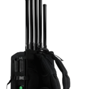
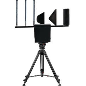
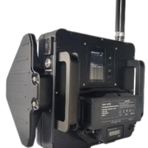
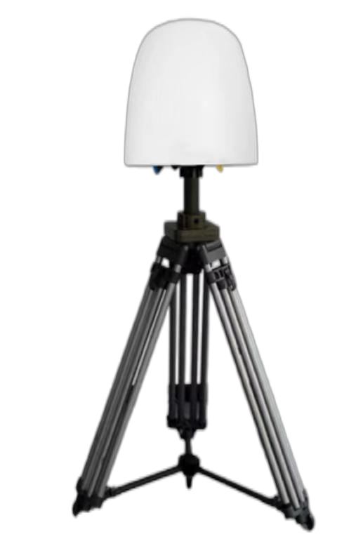
Packaging and Deployment Specifications
Professional-grade radar systems demand careful attention to packaging and installation details that ensure reliable operation in challenging environments.
Physical Configuration
| Component | Specification | Purpose |
|---|---|---|
| Antenna Array | Weather-resistant radome | Environmental protection while maintaining RF transparency |
| Processing Unit | 19″ rack-mount chassis | Standard data center integration |
| Power Supply | Dual-redundant 220VAC | Continuous operation during power fluctuations |
| Networking | Gigabit Ethernet | High-bandwidth data transmission to command centers |
| Mounting Hardware | Galvanized steel with vibration isolation | Long-term structural integrity |
User Guide: Operational Best Practices
Maximizing detection effectiveness requires understanding optimal deployment strategies and operational procedures.
Site Selection Criteria
The ideal installation location balances several factors:
- Elevation Advantage: Positioning 10-15 meters above ground level extends the radio horizon and minimizes ground clutter
- Clear Line of Sight: Avoiding nearby structures that could create RF shadows or multipath reflections
- Electromagnetic Environment: Conducting pre-installation RF surveys to identify potential interference sources
- Physical Security: Ensuring the installation site itself is protected against tampering or vandalism
System Calibration Procedures
Initial commissioning involves several critical steps:
- Baseline RF Survey: Document the ambient RF environment across all frequencies
- Known Target Testing: Fly authorized drones at measured distances and bearings to verify performance
- Integration Verification: Confirm data flow to command and control systems
- Alarm Threshold Optimization: Balance sensitivity against false alarm rates
Maintenance: Ensuring Long-Term Reliability
Like any precision electronic system, low-altitude radar requires systematic maintenance to sustain peak performance.
Preventive Maintenance Schedule
| Interval | Activity | Expected Duration |
|---|---|---|
| Daily | Remote system health check via network | 5 minutes |
| Weekly | Review detection logs for anomalies | 30 minutes |
| Monthly | Clean antenna radome and inspect connections | 2 hours |
| Quarterly | Calibration verification with test targets | 4 hours |
| Annually | Comprehensive system overhaul and firmware updates | 8 hours |
Common Fault Scenarios and Remediation
Understanding typical failure modes enables rapid troubleshooting:
- Degraded Sensitivity: Often caused by water ingress or corroded connections
- Bearing Errors: May indicate antenna array damage or calibration drift
- Intermittent Detection: Could suggest power supply issues or electromagnetic interference
- Network Connectivity Loss: Verify cable integrity and switch configuration
Radar Application Scenarios: Real-World Case Studies
The true value of low-altitude radar emerges through examination of actual deployment scenarios and their outcomes.
Scenario 1: Industrial Facility Protection
A petrochemical refinery implemented TYGZ-322 systems at four corners of their 2km × 3km facility. The overlapping coverage created a detection mesh with no blind spots. During the first year of operation:
- 847 drone detections logged
- 12 confirmed security incidents prevented
- 3 cases of industrial espionage attempts thwarted
- Zero false alarms leading to facility shutdown
Scenario 2: Smart City Integration
An urban municipality integrated drone detection with existing traffic management infrastructure. The system now provides:
- Real-time airspace status on public safety dashboards
- Automated alerts to emergency responders
- Historical flight pattern analysis for urban planning
- Evidence collection for prosecution of airspace violations
Scenario 3: Border Security Enhancement
Deployment along a 50-kilometer border section demonstrated:
- 99.2% detection rate for drones crossing the perimeter
- Average detection range of 4.7 kilometers
- Successful tracking through handoff between adjacent radar units
- Integration with rapid response teams achieving 15-minute intercept times
Conclusions: The Future of Low-Altitude Domain Awareness
The evolution from simple drone detection to comprehensive low-altitude domain awareness represents a fundamental shift in how we conceptualize airspace security. Systems like the TYGZ-322 serve as the sensory foundation for this new paradigm, providing the persistent, wide-area surveillance necessary to maintain safety and security in an increasingly complex aerial environment.
As we look toward the future, several trends will shape the continued development of low-altitude radar technology:
- Artificial Intelligence Integration: Machine learning algorithms will enhance target classification and reduce false alarms
- Sensor Fusion: Combining RF detection with acoustic, optical, and thermal sensors for multi-phenomenology confirmation
- Networked Operations: Distributed radar networks sharing data for regional-scale awareness
- Counter-UAS Integration: Seamless handoff from detection to interdiction systems
The TYGZ-322 and similar systems represent not merely products, but platforms upon which comprehensive airspace security solutions are built. Their deployment marks a critical step in establishing the technological infrastructure necessary for safe integration of manned and unmanned aviation in shared airspace.
Frequently Asked Questions
Q1: How does the TYGZ-322 differentiate between authorized and unauthorized drones?
The system detects all drone RF signatures within range and maintains a whitelist database of authorized operators. When a signal is detected, the system checks against known authorized signatures, frequency patterns, and identification codes. Unauthorized drones either lack proper identification or operate on non-compliant frequencies, triggering alerts. Integration with drone registration databases enables real-time verification of operator credentials.
Q2: What is the minimum detectable drone size using this radar system?
The TYGZ-322 doesn’t detect drones based on physical size but rather their RF emissions. This means even micro-drones weighing less than 250 grams can be detected if they emit control signals within the 300MHz-6000MHz range. The limiting factor is signal strength rather than physical dimensions, making the system effective against the full spectrum of commercial and consumer drones.
Q3: Can the system operate effectively in heavy RF interference environments?
Yes, the system employs sophisticated digital signal processing techniques including adaptive filtering, frequency hopping detection, and spread spectrum analysis. In high-interference environments like urban areas, the system automatically adjusts detection thresholds and employs machine learning algorithms to distinguish drone signals from background noise. Typical urban deployment maintains >95% detection accuracy despite ambient RF congestion.
Q4: How many operators are required to monitor the system effectively?
The TYGZ-322 is designed for automated operation with minimal human oversight. A single operator can monitor multiple units through the centralized management software. For a typical installation covering a 5km radius, one operator can effectively manage the system during routine operations, with staffing increased to 2-3 operators during high-threat periods or special events.
Q5: What happens when multiple drones operate simultaneously in the detection zone?
The system’s ≥60 simultaneous target tracking capability means it can distinguish and track multiple drones operating on different frequencies or using different control protocols. Each drone appears as a separate track with unique identification parameters. The system maintains individual bearing and signal strength data for each target, preventing confusion even in swarm scenarios.
Q6: How does weather affect detection performance?
The RF detection methodology is largely immune to weather conditions that would degrade optical or acoustic sensors. Rain, fog, and snow have minimal impact on radio wave propagation at these frequencies. The specified -20°C to +50°C operating range ensures functionality in extreme temperatures. Only severe atmospheric conditions like temperature inversions might cause minor variations in detection range.
Q7: Can the radar detect drones using encrypted communications?
Yes, encryption affects the content of communications but not the presence of RF signals. The TYGZ-322 detects the carrier signal regardless of encryption status. While the system cannot decode encrypted command data, it can still determine the drone’s presence, bearing, and signal characteristics. This makes the system effective against both commercial drones with standard protocols and custom drones with proprietary encryption.
Q8: What is the typical installation timeframe for a complete system?
Professional installation typically requires 2-3 days for a single unit, including:
- Day 1: Site preparation, mounting hardware installation, cable routing
- Day 2: Equipment installation, power/network connections, initial configuration
- Day 3: Calibration, testing, operator training, and handover Multi-unit installations may require additional time for network integration and coverage optimization.
Q9: How does the system handle frequency-hopping or spread-spectrum drones?
Advanced signal processing algorithms specifically designed for frequency-agile targets enable detection of spread-spectrum and frequency-hopping signals. The system’s wide instantaneous bandwidth (300MHz-6000MHz) and fast scanning capability (≤2 second response time) ensure that even rapidly changing frequencies are captured. Pattern recognition algorithms identify the hopping sequence characteristic of specific drone models.
Q10: What integration options exist for existing security infrastructure?
The TYGZ-322 provides multiple integration pathways:
- Network API for direct software integration with VMS/PSIM platforms
- ONVIF compliance for IP camera system integration
- Dry contact outputs for legacy alarm system compatibility
- MQTT/REST protocols for IoT platform connectivity
- SDK availability for custom application development
This flexibility ensures seamless incorporation into existing security ecosystems without requiring wholesale infrastructure replacement.