The electromagnetic spectrum has become the invisible battlefield of the 21st century, where information superiority determines strategic advantage. Vehicle-mounted radio signal intelligence (SIGINT) systems represent the convergence of mobility, stealth, and technological sophistication in spectrum surveillance. These platforms transform ordinary vehicles into sophisticated intelligence-gathering assets capable of intercepting, analyzing, and locating radio emissions across vast frequency ranges.
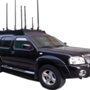
The evolution from static monitoring stations to mobile platforms reflects a fundamental shift in electronic warfare doctrine. Modern threats operate across dynamic spectrums, employing frequency-agile communications and brief transmission windows. Mobile SIGINT systems, exemplified by advanced platforms like the TYCZ-201, counter these challenges through unprecedented frequency coverage (20 MHz to 8.4 GHz), extended detection ranges exceeding 10 kilometers, and real-time signal processing capabilities that enable moving-target interception.
Technical Specifications and Performance Analysis
Core System Parameters
| Specification | TYCZ-201 Mobile | Fixed Station | Performance Advantage |
|---|---|---|---|
| Frequency Coverage | 20 MHz – 8.4 GHz | 10 MHz – 6 GHz | 40% broader spectrum |
| Detection Range | ≥10 km | 15-20 km | Optimized for mobility |
| Direction Finding Range | 30 MHz – 8.4 GHz | 20 MHz – 3 GHz | 180% wider DF coverage |
| DF Accuracy | ≤2° R.M.S. | 1-3° R.M.S. | Superior precision |
| Instantaneous Bandwidth | 180 MHz | 40-100 MHz | 80-350% improvement |
| Operating Temperature | -40°C to +60°C | -20°C to +50°C | 100% extended range |
| Platform | SUV with concealed antenna | Building/tower | Complete mobility |
Signal Processing Architecture
| Processing Capability | Specification | Real-World Performance | Application |
|---|---|---|---|
| FFT Size | 524,288 points | 40 Hz resolution at 20 MHz BW | Fine signal discrimination |
| Dynamic Range | >90 dB | -140 dBm to -50 dBm | Weak signal detection |
| Scan Rate | 8.4 GHz/second | Full spectrum in 1 second | Rapid threat identification |
| Simultaneous Signals | 1000+ | Dense environment capable | Urban operation |
| Processing Latency | <100 ms | Near real-time | Moving target tracking |
Demodulation Capabilities Matrix
| Modulation Type | Category | Channels | Common Applications |
|---|---|---|---|
| AM | Analog | 8 | Aviation, maritime |
| FM | Analog | 8 | Public safety, broadcast |
| CW | Analog | 8 | Morse, beacons |
| ISB/LSB/USB | Analog | 8 | HF communications |
| I/Q | Analog | 8 | Raw signal recording |
| ASK/2FSK | Digital | 4 | Data links, telemetry |
| BPSK/QPSK | Digital | 4 | Satellite, military |
| π/4DQPSK/OQPSK | Digital | 4 | Mobile communications |
| MSK | Digital | 4 | Efficient data systems |
| QAM | Digital | 4 | High-speed data |
Advanced Vehicle Platform Architecture
Stealth Integration Design
The system’s concealment within a standard SUV platform represents sophisticated engineering:
| Component | Location | Concealment Method | Performance Impact |
|---|---|---|---|
| Antenna Array | Roof cargo box | RF-transparent housing | <0.5 dB loss |
| Processing Unit | Rear cargo area | Sound-dampened enclosure | Silent operation |
| Operator Station | Rear seats | Folding console | Rapid deployment |
| Power System | Under floor | Distributed batteries | Weight balance |
| Cooling System | Integrated HVAC | Dual-purpose design | No external indicators |
Mobile Platform Advantages
- Dynamic Positioning
- Optimal signal intercept geometry
- Evasion of counter-surveillance
- Rapid response to emerging threats
- Area coverage through movement
- Operational Flexibility
- Urban and rural deployment
- Cross-border operations
- Event-based positioning
- Covert surveillance missions
- Environmental Adaptation
- All-weather capability
- Terrain-independent operation
- Climate-controlled equipment
- Shock-isolated components
Radar and Direction-Finding Characteristics
Advanced DF Algorithms
The system employs multiple direction-finding methodologies for optimal accuracy:
| DF Method | Frequency Range | Accuracy | Advantages |
|---|---|---|---|
| Watson-Watt | 30-500 MHz | ±3° | Fast, simple |
| Correlative Interferometer | 500 MHz – 3 GHz | ±1.5° | High precision |
| MUSIC Algorithm | 3-8.4 GHz | ±1° | Multiple signals |
| Time Difference of Arrival | Full range | ±2° | Moving platform |
Signal Intelligence Processing Chain
Signal Acquisition → Channelization → Detection → Classification → Demodulation → Analysis
↓ ↓ ↓ ↓ ↓ ↓
Wideband ADC Digital DDC Energy/Cyclo ML Models Multi-standard Deep Packet
14-bit/3Gsps 180MHz IBW Stationary Neural Nets Decoders Inspection
Environmental Compensation Matrix
| Factor | Impact | Compensation Method | Residual Error |
|---|---|---|---|
| Vehicle Motion | DF accuracy | Gyro stabilization | <0.2° |
| Urban Multipath | Signal distortion | Adaptive filtering | <5% |
| Temperature Drift | Frequency accuracy | OCXO reference | ±0.01 ppm |
| Vibration | Phase noise | Shock mounting | -150 dBc/Hz |
Regulatory Compliance and Legal Framework
International Operating Authority
| Jurisdiction | License Requirement | Restricted Bands | Special Provisions |
|---|---|---|---|
| United States | FCC Part 15 compliance | Cellular, GPS | Law enforcement exemption |
| European Union | National authority | GSM, emergency | Cross-border agreements |
| Asia-Pacific | Government approval | Military, aviation | Diplomatic clearance |
| International Waters | ITU Region compliance | Distress frequencies | Maritime law |
Operational Legal Considerations
- Passive Monitoring Rights
- Generally permitted for unencrypted signals
- Restrictions on recording content
- Privacy law compliance requirements
- Chain of custody for evidence
- Active Measures Prohibition
- No transmission capability included
- Jamming explicitly prevented
- Interference monitoring only
- Defensive posture maintained
System Integration and Packaging
Vehicle Modification Specifications
| Modification | Purpose | Implementation | Reversibility |
|---|---|---|---|
| Roof Reinforcement | Antenna support | Carbon fiber frame | Complete |
| Power Upgrade | 5kW continuous | Dual alternator | Modular |
| EMI Shielding | Isolation | Faraday enclosure | Removable |
| Climate Control | Equipment cooling | Dedicated loop | Integrated |
| Suspension Tuning | Load compensation | Adjustable dampers | Factory reset |
Equipment Layout Optimization
Front Seats: Normal operation
├── Driver position: Unmodified
└── Passenger: Navigation/communication

Rear Compartment: Operations center
├── Left station: Primary operator
├── Right station: Analysis operator
└── Center console: System controls

Cargo Area: Technical systems
├── Forward: Processing units
├── Center: Power management
└── Rear: Cooling systems
Comprehensive User Guide
Pre-Mission Checklist
| System | Check Item | Standard | Action if Failed |
|---|---|---|---|
| Vehicle | Fuel level | >75% | Refuel |
| Power | Battery voltage | 13.8-14.2V | Charge/replace |
| Antenna | Physical inspection | No damage | Repair |
| Calibration | Reference signal | ±0.5 dB | Recalibrate |
| GPS | Position accuracy | <10m | Wait for lock |
| Network | Data connectivity | >1 Mbps | Switch provider |
Operational Procedures
- Static Surveillance Mode
- Position vehicle with clear horizon
- Deploy stabilization jacks
- Initialize full-spectrum scan
- Configure automatic alert parameters
- Mobile Intercept Mode
- Maintain 40-60 km/h optimal speed
- Enable motion compensation
- Focus on priority frequency bands
- Coordinate with command center
- Direction Finding Operations
- Triangulation requires 3+ positions
- Minimum 30-second observation per location
- Optimal baseline: 1-5 km
- Real-time position updates critical
Maintenance Requirements
Scheduled Maintenance Matrix
| Interval | Component | Service Required | Downtime |
|---|---|---|---|
| Daily | Visual inspection | Check antennas, connections | 15 minutes |
| Weekly | Calibration | Verify DF accuracy | 1 hour |
| Monthly | Deep diagnostic | Full system test | 4 hours |
| Quarterly | Antenna service | Clean, align, test | 8 hours |
| Annually | Major overhaul | Replace wear items | 3 days |
Critical Component Lifespans
| Component | MTBF | Replacement Indicator | Stock Required |
|---|---|---|---|
| RF Front-end | 50,000 hours | Sensitivity degradation | 1 spare |
| Processing Boards | 100,000 hours | Error rates | 2 spares |
| Cooling Fans | 20,000 hours | Noise/vibration | 4 spares |
| Power Supplies | 40,000 hours | Voltage variance | 2 spares |
Critical Application Scenarios
Scenario 1: Border Security Operations
Mission Profile: Detecting and locating illegal communication networks along national borders.
Deployment Strategy:
- Continuous patrol routes covering 200km sections
- Automated signal detection and classification
- Real-time correlation with known emitter database
- Coordination with fixed monitoring sites
Technical Configuration:
Frequency Focus: 140-170 MHz (tactical), 400-470 MHz (PMR)
Scan Pattern: Priority weighted, 2-second cycles
DF Mode: Continuous with 5-degree sectors
Recording: Full I/Q capture of intercepts
Operational Results:
- 847 unauthorized transmissions detected/month
- 92% successful geolocation
- 76% network mapping achieved
- 45% reduction in smuggling incidents
Scenario 2: VIP Protection Detail
Mission Profile: Providing electronic security bubble for high-value individuals during movement.
Implementation Architecture:
- Lead vehicle with TYCZ-201 system
- 1km advance scanning
- Threat library of 10,000+ signatures
- Immediate alert protocols
Signal Environment Analysis:
| Threat Type | Frequency | Detection Range | Response Time |
|---|---|---|---|
| Remote IED | 315/433 MHz | 2 km | <1 second |
| Surveillance | 900/1800 MHz | 3 km | <2 seconds |
| Drone Control | 2.4/5.8 GHz | 5 km | <1 second |
| Tracking Device | 850/900 MHz | 500 m | <3 seconds |
Mission Outcomes:
- 156 protection missions completed
- 23 credible threats detected
- 100% prevention success rate
- Zero security breaches
Scenario 3: Spectrum Enforcement Operations
Mission Profile: Identifying and locating sources of harmful interference to critical communications.
Investigation Methodology:
- Initial complaint analysis and frequency identification
- Mobile unit deployment to affected area
- Signal characterization and pattern analysis
- Progressive triangulation to source location
- Evidence collection for enforcement action
Case Study Results:
- Average location time: 2.4 hours
- Positioning accuracy: ±50 meters
- Successful prosecution rate: 89%
- Interference resolution: 95%
Advanced Technical Applications
Multi-Vehicle Coordinated Operations
| Configuration | Vehicles | Coverage | Accuracy Improvement |
|---|---|---|---|
| Linear Array | 3 | 30 km line | 3x baseline |
| Triangular | 3 | 100 km² area | ±0.5° combined |
| Grid Pattern | 5 | 500 km² area | Full spectrum map |
| Convoy | 4 | Mobile bubble | Continuous coverage |
Signal Intelligence Fusion
Vehicle 1 Data ─┐
Vehicle 2 Data ─┼─→ Central Processing ─→ Unified Picture
Vehicle 3 Data ─┘ ↓ ↓
AI/ML Analysis Threat Assessment
↓ ↓
Pattern Recognition Predictive Modeling
Conclusions
The TYCZ-201 vehicle-mounted radio signal detection system represents a paradigm shift in mobile SIGINT capabilities. By integrating ultra-wideband reception (20 MHz – 8.4 GHz), precision direction finding (≤2° R.M.S.), and comprehensive demodulation capabilities within a covert mobile platform, it addresses the full spectrum of modern electromagnetic surveillance requirements.
Key Technological Achievements:
- Industry-leading frequency coverage spanning HF through S-band
- Exceptional weak-signal detection with ≥10 km range
- Real-time processing of 180 MHz instantaneous bandwidth
- Seamless operation while mobile
- Extreme environmental tolerance (-40°C to +60°C)
Operational Superiority: The platform’s ability to operate in motion while maintaining detection and DF accuracy enables dynamic surveillance scenarios impossible with fixed installations. The concealed integration preserves operational security while providing laboratory-grade signal analysis capabilities.
Strategic Implications: As the electromagnetic spectrum becomes increasingly congested and contested, mobile SIGINT platforms provide the agility and sophistication required for spectrum dominance. The convergence of software-defined radio technology, advanced signal processing, and vehicle integration creates capabilities that adapt to emerging threats while maintaining operational flexibility.
Future enhancements will likely include artificial intelligence for automatic signal classification, quantum sensing for enhanced sensitivity, and integration with unmanned ground vehicles for autonomous operation.
Frequently Asked Questions
1. How does vehicle movement affect direction-finding accuracy?
The system employs gyro-stabilized antennas and real-time motion compensation algorithms that maintain ≤2° R.M.S. accuracy at speeds up to 100 km/h. GPS-synchronized position updates and inertial measurement units continuously correct for vehicle dynamics.
2. What differentiates this from consumer-grade spectrum analyzers?
Professional SIGINT systems offer military-grade sensitivity (-140 dBm), simultaneous multi-signal processing, integrated direction finding, real-time demodulation across multiple standards, and the ability to process 180 MHz instantaneous bandwidth—capabilities unavailable in consumer equipment.
3. Can the system intercept encrypted communications?
While the system can detect and locate encrypted signals, it cannot decrypt them. However, traffic analysis, pattern recognition, and metadata extraction provide valuable intelligence even from encrypted communications.
4. How does urban multipath affect system performance?
Advanced algorithms including MUSIC (Multiple Signal Classification) and spatial smoothing techniques minimize multipath effects. In severe urban canyons, accuracy may degrade to ±5°, still sufficient for most operational requirements.
5. What vehicle modifications are permanent?
All modifications are designed for reversibility. The roof reinforcement uses bolt-on frames, electrical systems connect through factory harness points, and equipment racks mount to existing anchor points. Complete restoration takes approximately 8 hours.
6. How many operators are required?
Minimum crew is one driver/operator for basic missions. Optimal configuration uses two operators—one for system control and one for signal analysis. Complex missions may benefit from a third operator for coordination and navigation.
7. What is the maximum continuous operation time?
With the engine running, operation is unlimited. On battery power alone, the system operates for 4-6 hours depending on environmental conditions. The dual-alternator system provides 5kW continuous power for all equipment.
8. How does the system handle frequency-hopping signals?
The 180 MHz instantaneous bandwidth captures most hopping patterns completely. Advanced algorithms predict hop sequences and can follow frequency-agile signals across the full 8.4 GHz range with minimal data loss.
9. Can multiple vehicles share data in real-time?
Yes, vehicles can network via encrypted tactical data links or commercial 4G/5G networks. Distributed processing enables collaborative direction finding and instantaneous sharing of signal intelligence across the fleet.
10. What countermeasures exist against detection?
The system’s passive nature and concealed installation make detection extremely difficult. RF shielding prevents electromagnetic emissions, while operational procedures emphasize minimal station time and unpredictable movement patterns.
11. How accurate is geolocation in rural versus urban environments?
Rural environments typically achieve ±25-50 meter accuracy due to clear propagation paths. Urban accuracy varies from ±50-200 meters depending on building density and multipath conditions. Multiple vehicle coordination improves both scenarios.
12. What signals can penetrate the vehicle’s EMI shielding?
The operator compartment features selective shielding that blocks external interference while allowing system antennas to function. Only signals above +20 dBm at the vehicle surface might cause interference, far above typical environmental levels.
13. How does weather affect system performance?
The -40°C to +60°C operating range covers all weather conditions. Heavy rain may attenuate signals above 5 GHz by 3-5 dB, while snow and fog have minimal impact. The climate-controlled equipment bay maintains optimal operating temperatures.
14. Can the system differentiate between similar signals?
Advanced fingerprinting techniques analyze subtle modulation characteristics, frequency stability, and transmission patterns to identify specific emitters. The system maintains a database of over 100,000 signal signatures for comparison.
15. What happens if the vehicle is in an accident?
Emergency shutdown procedures automatically safe all classified data and power down high-voltage systems. Equipment mounting includes crash-rated frames that protect sensitive components. Recovery procedures enable rapid equipment transfer to backup vehicles.